We have learned how Frank has become an artist and illustrator on our interview blog [Part 1]. In Part 2, we will look at his way of map-making!
MAP MAKING
![]() Can you tell me why you draw maps? Was there anything that made you start to draw maps?
Can you tell me why you draw maps? Was there anything that made you start to draw maps?
![]() I remember drawing maps as a kid. The first map I drew was treasure maps. I made lots of them. I have always been a fan of little islands. I guess when I was drawing treasure maps, it was like building a world. I was in control and felt like I am the god of the space making my own country or world. I tried to refine the maps many times and draw different mountain ranges, deers, and rivers…
I remember drawing maps as a kid. The first map I drew was treasure maps. I made lots of them. I have always been a fan of little islands. I guess when I was drawing treasure maps, it was like building a world. I was in control and felt like I am the god of the space making my own country or world. I tried to refine the maps many times and draw different mountain ranges, deers, and rivers…
![]() Like kids these days play Minecraft.
Like kids these days play Minecraft.
![]() That is right. You can build mountains, anything you want. I have always felt compelled to draw somehow. I have a terrible sense of direction. When I am in a city, I get lost easily, and maybe that is why I love maps. When I see a map, I always pick it up. Also, when you look at a map, or when you draw a map, you can imagine the bird’s eye view like you are flying above it. I used to paint a lot of flying people and birds. I have never been able to fly, but maybe I like to imagine myself flying. I love the fact that you can illustrate maps and put my own story or myself into the map. It is more like depicting experiences.
That is right. You can build mountains, anything you want. I have always felt compelled to draw somehow. I have a terrible sense of direction. When I am in a city, I get lost easily, and maybe that is why I love maps. When I see a map, I always pick it up. Also, when you look at a map, or when you draw a map, you can imagine the bird’s eye view like you are flying above it. I used to paint a lot of flying people and birds. I have never been able to fly, but maybe I like to imagine myself flying. I love the fact that you can illustrate maps and put my own story or myself into the map. It is more like depicting experiences.
![]() I find that your maps have lots of stories and experiences that happen at different places.
I find that your maps have lots of stories and experiences that happen at different places.
![]() The maps I have been doing are quite literal. They explain what is around and happening there. I like to put stories, like telling secret places or describing things that happen there. They don’t really need to be historical things, it can just be anything.
The maps I have been doing are quite literal. They explain what is around and happening there. I like to put stories, like telling secret places or describing things that happen there. They don’t really need to be historical things, it can just be anything.
![]() Your maps always have some animals or people in action.
Your maps always have some animals or people in action.
![]() Yes, I love putting life into the map.
Yes, I love putting life into the map.
![]() For example, your Australian map of Noosa is vibrant and there are lots of fun things going on.
For example, your Australian map of Noosa is vibrant and there are lots of fun things going on.
![]() Yes, that was more of my personal experience. The first or second day we were there, we had a big run and went to the National Park. I was listening to music, feeling pumped, and when I got to the top of the track, I saw a whale in the sea, and when I turned around I saw an eagle flying over. It was amazing. I always loved Noosa. I love the nature there and looking at the birds.
Yes, that was more of my personal experience. The first or second day we were there, we had a big run and went to the National Park. I was listening to music, feeling pumped, and when I got to the top of the track, I saw a whale in the sea, and when I turned around I saw an eagle flying over. It was amazing. I always loved Noosa. I love the nature there and looking at the birds.
![]() I can tell all of that excitement just by looking at the map. When you go through a process of drawing maps, do you already have a picture in your mind of how it is going to look like at the end? Or do you research and collect a lot of information before you start drawing? Do you take photos for example?
I can tell all of that excitement just by looking at the map. When you go through a process of drawing maps, do you already have a picture in your mind of how it is going to look like at the end? Or do you research and collect a lot of information before you start drawing? Do you take photos for example?
![]() I take a lot of photos. I look at the actual survey maps or professional maps. There is no point for me to draw maps like the actual cartographers. I consider them artisans, but it needs to be more than that. I try to think of stories. I try to research and think of what is happening there. I take photos and try to include all the important things. Sometimes I get anxious if I have left something out, or something is not quite in the right place. But again, it is an illustration and more of an emotional thing.
I take a lot of photos. I look at the actual survey maps or professional maps. There is no point for me to draw maps like the actual cartographers. I consider them artisans, but it needs to be more than that. I try to think of stories. I try to research and think of what is happening there. I take photos and try to include all the important things. Sometimes I get anxious if I have left something out, or something is not quite in the right place. But again, it is an illustration and more of an emotional thing.
![]() I guess when you draw a map of Dunedin, you can always see with your own eyes if something is right or not because you are a local. Is it more difficult to draw a map of the place where you have travelled?
I guess when you draw a map of Dunedin, you can always see with your own eyes if something is right or not because you are a local. Is it more difficult to draw a map of the place where you have travelled?
![]() It is more difficult because in Dunedin, I know what is going on. I know a bit of what is going on in Noosa, and I know that if I draw people and animals, nobody can argue my experience because that is what happened there. The Noosa map was a personal project, but I also thought maybe someone would buy it. That is why I thought it needs to be correct.
It is more difficult because in Dunedin, I know what is going on. I know a bit of what is going on in Noosa, and I know that if I draw people and animals, nobody can argue my experience because that is what happened there. The Noosa map was a personal project, but I also thought maybe someone would buy it. That is why I thought it needs to be correct.
![]() Was the Noosa map your personal experience with lots of research involved?
Was the Noosa map your personal experience with lots of research involved?
![]() Yes, research, finding out what birds and animals were there, and trying to get the tracks right just in case one day someone would use that map.
Yes, research, finding out what birds and animals were there, and trying to get the tracks right just in case one day someone would use that map.
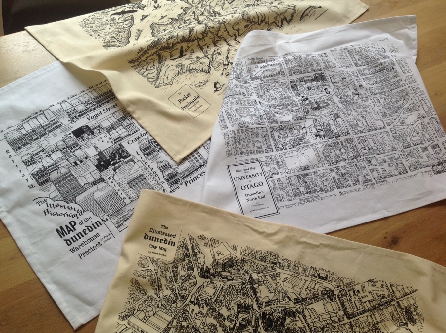
![]() Yesterday, I walked around the Dunedin Warehouse Precinct area with your Heritage Precinct map on Stroly. I have noticed that all the buildings you have put on your map were very much in detail. It was so easy to spot all the places.
Yesterday, I walked around the Dunedin Warehouse Precinct area with your Heritage Precinct map on Stroly. I have noticed that all the buildings you have put on your map were very much in detail. It was so easy to spot all the places.
![]() Excellent. It is great you have walked around with it.
Excellent. It is great you have walked around with it.
![]() I took photos of the buildings. It was really fun and informative. If you are into the history of this city, you would want to learn more about it. I really enjoyed that side of the experience.
I took photos of the buildings. It was really fun and informative. If you are into the history of this city, you would want to learn more about it. I really enjoyed that side of the experience.
![]() That map was a commission. Every year, they have a big street party called Vogel Street Party in that area. I go out there selling my maps.
That map was a commission. Every year, they have a big street party called Vogel Street Party in that area. I go out there selling my maps.
![]() How long does it take for you to create one map?
How long does it take for you to create one map?
![]() Between one to six months. I think the Noosa map did not take me so long but the Dunedin map obviously took longer.
Between one to six months. I think the Noosa map did not take me so long but the Dunedin map obviously took longer.
![]() Which one is your favorite map?
Which one is your favorite map?
![]() The Dunedin map gave me the most income. It is constantly being sold. But I love the Noosa map more. It has not made any money, but I just love it because sometimes I look at it, and I wish I were in Noosa. Also, I love the Pocket Peninsula Illustrated Map.
The Dunedin map gave me the most income. It is constantly being sold. But I love the Noosa map more. It has not made any money, but I just love it because sometimes I look at it, and I wish I were in Noosa. Also, I love the Pocket Peninsula Illustrated Map.
![]() This is a bit of a silly question, but do you enjoy illustrating maps?
This is a bit of a silly question, but do you enjoy illustrating maps?
![]() I honestly love it. Whenever I see illustrated maps, I need to have them. When you guys have new maps, I get really excited. I can do it all day, every day. I want to draw all the maps in the world.
I honestly love it. Whenever I see illustrated maps, I need to have them. When you guys have new maps, I get really excited. I can do it all day, every day. I want to draw all the maps in the world.
![]() Would you ever want to draw a map of a place where you have never been to?
Would you ever want to draw a map of a place where you have never been to?
![]() I have never thought of that, but I could actually do that. It could be a map of somewhere you want to go to and draw things you want to do there.
I have never thought of that, but I could actually do that. It could be a map of somewhere you want to go to and draw things you want to do there.
![]() Some people do that, and they sometimes find it challenging because they have never been there. Where would be the place you want to draw in the future if you had a choice?
Some people do that, and they sometimes find it challenging because they have never been there. Where would be the place you want to draw in the future if you had a choice?
![]() I would like to draw a map of Iceland.
I would like to draw a map of Iceland.
![]() Iceland! Have you ever been there before?
Iceland! Have you ever been there before?
![]() No, but it looks like one of the maps you would draw as a kid. Rugged courses, crazy volcanoes and mountains, and the natural wonders.
No, but it looks like one of the maps you would draw as a kid. Rugged courses, crazy volcanoes and mountains, and the natural wonders.
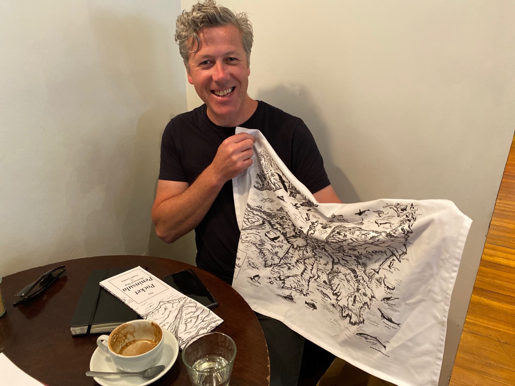
(Frank’s maps come in tea towels too)
![]() Is there any other place where you have been to and you want to draw?
Is there any other place where you have been to and you want to draw?
![]() I would love to draw Tokyo because I have lots of personal stories from there. One story, my god it was so funny, I went to Yoyogi Park, and I was sitting there having something to eat, and this woman was sitting on her own. I was carrying binoculars with me to look at the birds, and she also took her binoculars out. It was the most Japanese thing that you could ever imagine. She could not speak a word of English, and I could not speak a word of Japanese. I was trying to explain to her that I was going to the art gallery and Ueno Zoo after this. She thought I meant, “Let’s go to the zoo together,” and we ended up going there together. We have spent the late afternoon not knowing what each other was talking about. Just pointing at things. It was the weirdest and most lovely experience. So, I would put that story on a map.
I would love to draw Tokyo because I have lots of personal stories from there. One story, my god it was so funny, I went to Yoyogi Park, and I was sitting there having something to eat, and this woman was sitting on her own. I was carrying binoculars with me to look at the birds, and she also took her binoculars out. It was the most Japanese thing that you could ever imagine. She could not speak a word of English, and I could not speak a word of Japanese. I was trying to explain to her that I was going to the art gallery and Ueno Zoo after this. She thought I meant, “Let’s go to the zoo together,” and we ended up going there together. We have spent the late afternoon not knowing what each other was talking about. Just pointing at things. It was the weirdest and most lovely experience. So, I would put that story on a map.
![]() What a lovely experience. You can draw some characters and the story on a map.
What a lovely experience. You can draw some characters and the story on a map.
![]() Absolutely. I also want to tell you about another map that I want to do. A musical map with songs. There are a couple of old Scottish songs. One of them is called, The Road to the Isles. It describes how this person wants to go to all these places in Scotland. I wish I could draw these places with all the song lyrics. That is something I want to work on.
Absolutely. I also want to tell you about another map that I want to do. A musical map with songs. There are a couple of old Scottish songs. One of them is called, The Road to the Isles. It describes how this person wants to go to all these places in Scotland. I wish I could draw these places with all the song lyrics. That is something I want to work on.
![]() Sounds like a nice plan. You can play the tunes using landmark pins on Stroly!
Sounds like a nice plan. You can play the tunes using landmark pins on Stroly!
There are a lot of people out there who want to draw maps, but they don’t know where to start. Do you have any advice for them?
![]() My advice would be to just draw a map of a local area. If you have something to say or a story to tell, then just put it on a map. If you are too shy to actually give it a try, just leave the map alone anonymously. You don’t need to put your name on. If you are too shy to share it on social media, someone will pick it up, and they will share it on social media.
My advice would be to just draw a map of a local area. If you have something to say or a story to tell, then just put it on a map. If you are too shy to actually give it a try, just leave the map alone anonymously. You don’t need to put your name on. If you are too shy to share it on social media, someone will pick it up, and they will share it on social media.
![]() We also have staff at Stroly who draw maps. They are based in Japan, but it is hard for them to draw a place other than Japan because they feel they don’t know enough about other places.
We also have staff at Stroly who draw maps. They are based in Japan, but it is hard for them to draw a place other than Japan because they feel they don’t know enough about other places.
![]() Sure. I don’t think it matters because they are not meant to be cartographers. We are just people who want to share your own experience.
Sure. I don’t think it matters because they are not meant to be cartographers. We are just people who want to share your own experience.
![]() That is good advice. Thank you.
That is good advice. Thank you.
When you create a map do you think about users? Some map creators think about who is going to use their map, and collect the information based on what exactly these users are looking for.
![]() To a certain extent, I do. Certainly, with the Otago University map, I did that because I thought about the students who come to Otago from all over New Zealand. I thought they would love to have a wee map of the place.
To a certain extent, I do. Certainly, with the Otago University map, I did that because I thought about the students who come to Otago from all over New Zealand. I thought they would love to have a wee map of the place.
![]() Did you specifically choose cafes and shops that the students would like?
Did you specifically choose cafes and shops that the students would like?
![]() Yes, the popular ones. The map is mainly for the students looking for somewhere to go. But the Dunedin map, that was for the tourists. When it first came out, it was all actually for ex-Dunedin people. I have sent it overseas to people who used to live in Dunedin.
Yes, the popular ones. The map is mainly for the students looking for somewhere to go. But the Dunedin map, that was for the tourists. When it first came out, it was all actually for ex-Dunedin people. I have sent it overseas to people who used to live in Dunedin.
![]() So, are all the places that are included in the Dunedin map popular among the locals?
So, are all the places that are included in the Dunedin map popular among the locals?
![]() Yes, I put the names so people know what they are looking for. I guess I wanted to tell everyone about the Dunedin experience.
Yes, I put the names so people know what they are looking for. I guess I wanted to tell everyone about the Dunedin experience.
![]() Like where to grab a nice coffee?
Like where to grab a nice coffee?
![]() Yes.
Yes.
![]() What is your favorite map on Stroly?
What is your favorite map on Stroly?
![]() There was one called Wander Compass. It is the one in Shibuya, Tokyo.
There was one called Wander Compass. It is the one in Shibuya, Tokyo.
![]() The one that looks a bit like Where’s Wally.
The one that looks a bit like Where’s Wally.
![]() Yes, that is it. I just love it.
Yes, that is it. I just love it.
![]() There is so much detail and fun stuff happening on this map.
There is so much detail and fun stuff happening on this map.
![]() This map reminds me of the game culture in Japan. Look at all these people wandering around. It is absolutely beautiful. It has everything. I understand the dilemma of the map maker because he/she probably did not want to leave anything out. I am so amazed by the work that is put into it. It is just beautiful. I love it.
This map reminds me of the game culture in Japan. Look at all these people wandering around. It is absolutely beautiful. It has everything. I understand the dilemma of the map maker because he/she probably did not want to leave anything out. I am so amazed by the work that is put into it. It is just beautiful. I love it.
OUR SERVICE
![]() What do you like about our service?
What do you like about our service?
![]() What is not to like. I just love everything that you guys do. I see you guys love maps as much as I love. You bring together lots of great map creators.
What is not to like. I just love everything that you guys do. I see you guys love maps as much as I love. You bring together lots of great map creators.
![]() That is what we try to do. We spread the love for illustrated maps and try to bring map creators together to create a community.
That is what we try to do. We spread the love for illustrated maps and try to bring map creators together to create a community.
![]() You are promoting maps while you promote the stories and experiences of different places. Also, the biggest and most important thing is your encouragement.
You are promoting maps while you promote the stories and experiences of different places. Also, the biggest and most important thing is your encouragement.
It feels really good to communicate with you guys because you are so enthusiastic. I could not believe that you take my maps and geo-map all of that.
![]() We absolutely love your maps. The maps we particularly like are the ones that make us feel we want to visit. After seeing your map of Noosa, I have actually searched about Noosa because I thought it would be nice to be there one day. At Stroly, we love maps that trigger your actions, behaviors, and the way you see the world.
We absolutely love your maps. The maps we particularly like are the ones that make us feel we want to visit. After seeing your map of Noosa, I have actually searched about Noosa because I thought it would be nice to be there one day. At Stroly, we love maps that trigger your actions, behaviors, and the way you see the world.
![]() It does something in your heart. It is the experiences and emotions. I love human stories. Maps make people think about the place. What did I do there? Did I really get involved with the community, did I speak to anyone who lived there, or did I just go there and do the touristic kind of thing and leave?
It does something in your heart. It is the experiences and emotions. I love human stories. Maps make people think about the place. What did I do there? Did I really get involved with the community, did I speak to anyone who lived there, or did I just go there and do the touristic kind of thing and leave?
![]() I think the mixture of the storytelling side of illustrated maps and the technology we have, it can make a difference in people’s behaviors. When you stroll somewhere with a map on Stroly, you might end up spending two hours when you originally thought you would only be there for 15 minutes.
I think the mixture of the storytelling side of illustrated maps and the technology we have, it can make a difference in people’s behaviors. When you stroll somewhere with a map on Stroly, you might end up spending two hours when you originally thought you would only be there for 15 minutes.
![]() The maps on Stroly enrich people’s experience because they feel more involved with the place rather than just looking through the glass. You actually feel you have discovered something in real-time.
The maps on Stroly enrich people’s experience because they feel more involved with the place rather than just looking through the glass. You actually feel you have discovered something in real-time.
![]() What is fascinating about illustrated maps is that it is like you are following in somebody’s footsteps.
What is fascinating about illustrated maps is that it is like you are following in somebody’s footsteps.
![]() Yes, exactly. You can imagine what somebody has experienced by looking at maps. I am just blown away by the stuff you do, so all I can say is keep doing it. It is wonderful.
Yes, exactly. You can imagine what somebody has experienced by looking at maps. I am just blown away by the stuff you do, so all I can say is keep doing it. It is wonderful.
![]() Lastly, would you like to say anything to our map creators community?
Lastly, would you like to say anything to our map creators community?
![]() I love maps. I think illustrated maps can be everything. They help you think about how a certain place got there, who made it, why we are still here, what is good about the place, did the place change how you think about certain things there, did the place make you think about the people and animals there, or what impact did the place have on you. That sort of context is what I try to give to the maps as I draw more like the surroundings, who else is there, how did they get there, animals and birds, and is there anything you can do to make the place better, whether you live there or not. When you visit a place you don’t need to just hop in and out. You can actually get involved.
I love maps. I think illustrated maps can be everything. They help you think about how a certain place got there, who made it, why we are still here, what is good about the place, did the place change how you think about certain things there, did the place make you think about the people and animals there, or what impact did the place have on you. That sort of context is what I try to give to the maps as I draw more like the surroundings, who else is there, how did they get there, animals and birds, and is there anything you can do to make the place better, whether you live there or not. When you visit a place you don’t need to just hop in and out. You can actually get involved.
![]() Do you think maps can be a tool to communicate an important message to users?
Do you think maps can be a tool to communicate an important message to users?
![]() They certainly can. Whether we notice or not, whenever we go somewhere, we leave some sort of impact. Whether that is meeting a stranger in a cafe and having conversations, going to a shop and purchasing something, or exchanging something with somebody. You always give an impact, like helping someone from falling over. I would like to see more people sharing their experiences. We can do that to some extent through social media, but there is more communication through maps. I also like paper maps because they are tangible. I guess what I am saying is the human experience that is important.
They certainly can. Whether we notice or not, whenever we go somewhere, we leave some sort of impact. Whether that is meeting a stranger in a cafe and having conversations, going to a shop and purchasing something, or exchanging something with somebody. You always give an impact, like helping someone from falling over. I would like to see more people sharing their experiences. We can do that to some extent through social media, but there is more communication through maps. I also like paper maps because they are tangible. I guess what I am saying is the human experience that is important.
![]() Yes, what you have just said is powerful. I would not have thought that way. You go somewhere, and you always give some kind of influence on the environment. The stories from illustrated maps tell us something about who we are, what we consider important and valuable, or what we thought and imagined about the place or events that took place. When I saw this beautiful map of Kiewa Valley in Australia where there was a bushfire, and the artist told me she had to evacuate, it made me think about the things happening globally.
Yes, what you have just said is powerful. I would not have thought that way. You go somewhere, and you always give some kind of influence on the environment. The stories from illustrated maps tell us something about who we are, what we consider important and valuable, or what we thought and imagined about the place or events that took place. When I saw this beautiful map of Kiewa Valley in Australia where there was a bushfire, and the artist told me she had to evacuate, it made me think about the things happening globally.
![]() Yes, you think about what happened then, what was lost, or you think about what you would have done in the situation. It makes you think if you could help in any way, is there anything you can do right now, or think about what we are doing to the climate, etc.
Yes, you think about what happened then, what was lost, or you think about what you would have done in the situation. It makes you think if you could help in any way, is there anything you can do right now, or think about what we are doing to the climate, etc.
![]() Yes, illustrated maps can convey lots of important messages and tell stories that make a difference. Thank you so much, Frank. I look forward to seeing more of your maps on Stroly!
Yes, illustrated maps can convey lots of important messages and tell stories that make a difference. Thank you so much, Frank. I look forward to seeing more of your maps on Stroly!
Check out the latest information about Frank Gordon.
Instagram
HP
His map of the lockdown and supporting local businesses in New Zealand is on Stroly.
Stay tuned for his upcoming exhibition at Gallery De Novo
Frank’s maps can be purchased in tea towels too.