Maps are helpful to find a route from one place to the other but illustrated maps on Stroly.com offer much more. Stroly maps help you learn about an area, navigate iconic locations, or recommend places close to you. These maps also help you remember the good feelings you had during your trip.
Here’s how Stroly maps helped me plan, enjoy, and remember my trip to Mexico City.
Stroly Maps Help You Learn About the Area
When you travel to a different country, learning about the area is essential to maximize your experience during your trip. Stroly maps are a great tool for learning more about an area.
When I was planning to visit Mexico for a holiday, this “Complete Map of Mexico” gave me a clearer idea of what each region offers at a glance. In general, illustrated map creators who design Stroly maps are familiar with the location because they have investigated or experienced living or visiting the area.
Maps in magazines or in other media are sponsored with excessive advertisements that could be overly enhanced. Stroly maps, however, are more reliable and informative because the creators carefully select what illustrations, recommendations, and locations to include in the map.
Stroly Maps Help You Find Iconic Landmarks Nearby
One great feature with Stroly maps is you can search illustrated maps based on your current location. When I arrived in Mexico City, my friend took me to Chapultepec Castle, which has a great view of the city. Afterwards, I opened Stroly.com on my phone.
We found an “Illustrated Map of Mexico City” and noticed an image of a building with the Mexican flag close to us! We wondered what it was and kept walking until we found out it was “Los Pinos,” the official presidential residence. It was a fun surprise because we wouldn’t have known it was there if I hadn’t opened this Stroly map.
If you’re someone who likes recommendations or secret places only locals know, go to Stroly.com. You may find a little surprise as you spontaneously walk around! Remember to have your location information turn on your phone!
Stroly Maps Help You Remember Your Trip
When was the last time you reminisced about previous trips? It’s easy to forget the good memories you made when you’re going through everyday life, but one of the real pleasures of traveling is to look back on those fond memories.
Stroly maps help you remember those feelings!
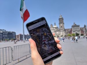
In my case, when I see the illustrations on the “Map of Mexico City’s Centro Historico – 1994”, I remember the feeling of being in Mexico City. The mariachi illustration reminds me of the loud and vibrant sounds of the city. The image of Zocalo and the Mexican flag reminds me of the thrill of me standing in the middle of the city center.
Unlike regular street maps, illustrated maps trigger emotions you experienced during your trip because those images are strongly and specifically related to the area. Think of your favorite place you’ve been to, and search it on Stroly.com to find an illustrated map! It will be an opportunity to look back on the fun memories that you may have forgotten.
At any stage of the trip, Stroly maps help you maximize your travel experience. Where is the next destination? Let’s open up Stroly.com and find a place that excites you!